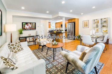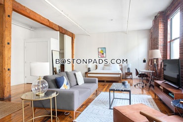


Property Description
Map & Nearby Areas
Mason Elementary School
Public Elementary School, Grades: PK-5
0.09mi
Community Academy
Public School, Grades: 9-12
0.14mi
Expulsion Alternative School
School
0.14mi
Dudley Street Neighborhood Charter School
Charter School, Grades: PK-5
0.16mi
Ralph Waldo Emerson School
Public School, Grades: K-5
0.16mi
St Patrick Elementary
Private School, Grades: PK-8
0.18mi
Boston University Medical Campus
University
0.4mi
Orchard Gardens K-8 School
Public Elementary School, Grades: PK-8
0.4mi
Dunkin'
Donut & Coffee Shop
0.44mi
MBTA Transit Police Headquarters
Police
0.6mi
Boston Fire Department Headquarters
Fire Station
0.35mi
Engine 14 and Ladder 4
Fire Station
0.52mi
Boston Medical Center
Hospital
0.51mi
Commonwealth Community Care
Hospital
0.54mi
Shirley-Eustis House
Museum
0.16mi
Clifford Playground
Municipal Park
0.11mi
Dudley Town Common
Municipal Park
0.12mi
Dennis Street Park
Municipal Park
0.24mi
Orchard Park
Municipal Park
0.27mi
William Eustis Playground
Playground
0.12mi
William Eustis Playground
Playground
0.13mi
Howes Playground
Playground
0.33mi
Little Scobie Playground
Playground
0.44mi
Bank of America
Bank
0.4mi
Sunoco
Gas Station. Self Service: Yes
0.39mi
Stop & Shop Gas
Gas Station
0.42mi
Stop & Shop
Supermarket
0.41mi
Dudley St @ Magazine St
0.11mi
Dudley St @ Blue Hill Ave
0.12mi
Blue Hill Ave @ Mt Pleasant Ave
0.13mi
Dudley St @ Hampden St
0.13mi
Blue Hill Ave @ Dudley St
0.14mi
Dudley St @ Langdon St
0.15mi
Dudley St @ Dennis St
0.16mi
Blue Hill Ave @ Winthrop St
0.23mi
Nearby Areas
Rent Calculator & Affordability
Rent Calculator
How much do you (or your cosigner) earn each year before taxes?

Related Properties
Apartment for Rent, Available Now at The Parkway, added 59 minutes ago, $3,094 per month, 1 Bed, 1 Bath, , , 1 Dishwasher, , Laundry, Air Conditioning, Flexible Move-In Date
Skip to Next ListingLuxury Apartment for RentAvailable: Now$3,094*No Fee1 Bed1 BathThe ParkwayView All1555 VFW Parkway, Boston, MA 02302Parking, Laundry, Air Conditioning, Flexible Move-In DateApartment for Rent, Available Now at Hancock Village Townhomes, added 59 minutes ago, $3,810 per month, 1 Bed, 1 Bath, , , 1 Dishwasher, Pet Friendly, Laundry, Air Conditioning, Flexible Move-In Date
Skip to Next ListingLuxury Apartment for RentAvailable: Now$3,810*1 Bed1 BathHancock Village TownhomesView All259 Independence Dr., Chestnut Hill, MA 02467Pet Friendly, Laundry, Air Conditioning, Flexible Move-In DateApartment for Rent, Available Now at Hancock Village Townhomes, added 59 minutes ago, $3,685 per month, 2 Beds, 1 Bath, , , 1 Dishwasher, Pet Friendly, Laundry, Air Conditioning, Flexible Move-In Date
Skip to Next ListingLuxury Apartment for RentAvailable: Now$3,685*2 Beds1 BathHancock Village TownhomesView All259 Independence Dr., Chestnut Hill, MA 02467Pet Friendly, Laundry, Air Conditioning, Flexible Move-In DateApartment for Rent, Available Now at Piano Craft Guild, added 59 minutes ago, $3,900 per month, 1 Bed, 1 Bath, , Heat & HW Included, 1 Dishwasher, Cat Friendly, Laundry, , Flexible Move-In Date
Skip to Next ListingLuxury Apartment for RentAvailable: Now$3,900*1 Bed1 BathPiano Craft GuildView All791 Tremont St., Boston, MA 02118Cat Friendly, Laundry, Flexible Move-In DateApartment for Rent, Available Now at Hancock Village Townhomes, added 59 minutes ago, $3,105 per month, 1 Bed, 1 Bath, , , 1 Dishwasher, Pet Friendly, Laundry, Air Conditioning, Flexible Move-In Date
Skip to Next ListingLuxury Apartment for RentAvailable: Now$3,105*1 Bed1 BathHancock Village TownhomesView All259 Independence Dr., Chestnut Hill, MA 02467Pet Friendly, Laundry, Air Conditioning, Flexible Move-In DateApartment for Rent, Available Now at West Roxbury, Boston, MA, added 4 hours ago, $3,600 per month, 3 Beds, 2 Baths, , , 1 Dishwasher, , Laundry, , Flexible Move-In Date
Skip to Next ListingApartment for RentAvailable: Now$3,60050% Fee3 Beds2 BathsWest Roxbury, Boston, MAParking, Laundry, Flexible Move-In DateApartment for Rent, Available Now at Fort Hill, Boston, MA, added 5 hours ago, $3,450 per month, 3 Beds, 1 Bath, , , Dishwasher, Pet Friendly, Laundry, , Flexible Move-In Date
Skip to Next ListingApartment for RentAvailable: Now$3,4503 Beds1 BathFort Hill, Boston, MAPet Friendly, Parking, Laundry, Flexible Move-In DateApartment for Rent, Available Now at The Parkway, added 14 hours ago, $3,404 per month, 2 Beds, 2 Baths, , , 1 Dishwasher, , Laundry, Air Conditioning, Flexible Move-In Date
Skip to Next ListingLuxury Apartment for RentAvailable: Now$3,404*No Fee2 Beds2 BathsThe ParkwayView All1555 VFW Parkway, Boston, MA 02302Parking, Laundry, Air Conditioning, Flexible Move-In DateApartment for Rent, Available 11-01-2024 at Roxbury, Boston, MA, added 3 days ago, $3,000 per month, 3 Beds, 1 Bath, , , 1 Dishwasher, Pet Friendly, Laundry, ,
Skip to Next ListingApartment for RentAvailable: 11-01-2024$3,000No Fee3 Beds1 BathRoxbury, Boston, MAPet Friendly, Parking, LaundryApartment for Rent, Available 01-01-2025 at Grove Hall - Dorchester, Boston, MA, added 4 days ago, $3,100 per month, 3 Beds, 1 Bath, , , Dishwasher, Cat Friendly, Laundry, ,
Skip to Next ListingApartment for RentAvailable: 01-01-2025$3,1003 Beds1 BathGrove Hall - Dorchester, Boston, MACat Friendly, Parking, LaundryApartment for Rent, Available Now at Oak Row, added 4 days ago, $3,339 per month, 2 Beds, 2 Baths, , , 1 Dishwasher, Pet Friendly, Laundry, Air Conditioning, Flexible Move-In Date
Skip to Next ListingLuxury Apartment for RentAvailable: Now$3,339*No Fee2 Beds2 BathsOak RowView All1235 VFW Parkway, Boston, MA 02132Pet Friendly, Parking, Laundry, Air Conditioning, Flexible Move-In DateApartment for Rent, Available 12-15-2024 at Roxbury, Boston, MA, added 5 days ago, $3,800 per month, 2 Beds, 1 Bath, , Heat & HW Included, 1 Dishwasher, , Laundry, ,
Skip to Next ListingApartment for RentAvailable: 12-15-2024$3,8002 Beds1 BathRoxbury, Boston, MAParking, Laundry